Review of GPS navigation programs for Android OS. Choosing the best navigator for Android
GPS navigation on a smartphone is one of the most popular functions for modern people. After all, it is so important to be mobile and have up-to-date access to data about your location. Not only when exploring a foreign city, but also if you need to find some street in your own, traveling or following some route for work purposes, it is important to get to the required place as quickly as possible.
But how to find the most best navigator for Android? After all, there are a huge number of such navigators. And there is simply no time to test each one. That is why we carefully analyzed this software and especially for you we compiled the top navigators for Android in 2018-2019, which will help to significantly optimize traffic on pedestrian and automobile routes.
#10 – MapFactor
This program is free and can be used on phones and tablets on the Android platform. Since the cards are installed directly into the gadget’s memory (optionally on an SD card), it is quite possible to use them without an Internet connection, which is very convenient. Maps are updated periodically. As a rule, this happens once a month.
The functionality of the application allows you to plan your route in advance, choosing the most optimal option from the list of those offered to choose from. What is noteworthy is that if you exceed the speed limit, a characteristic sound warning appears. In addition, this free program fully satisfies the demand for full-fledged satellite navigation.

Important features of this program are:
- Drawing up a route plan;
- Intuitive navigation in various languages;
- Color schemes (day and night);
- You can add your own routes and places;
- Rotate the map in the direction of your movement;
- Permanent updates and periodic map improvements;
- Work in 2D and 3D display format.
#9 – SYGIC
The SYGIC program has a worthy place in the category of the best navigators for Android. This is a modern application that integrates 3D offline maps from TomTom. The functionality allows you to find your way even in a completely unfamiliar place. Since the developer is trying to be among the leaders, an innovative option is provided to give commands by voice. The main purpose of such an application is to help motorists. Using the functionality of the program, it is easy to control the situation on the road, create your route almost instantly, without wasting time on traffic jams.

- Ability to work offline without an active connection to the World Wide Web;
- Projection (navigation recommendations can be projected onto Windshield auto, this is the highlight of the program);
- Search for the most successful route among the many offered to choose from;
- Driver warnings about speed limits, sharp turns, cameras that monitor traffic;
- Maps are constantly updated;
- Built-in information about attractions.
No. 8 – OsmAnd
The program will be a good assistant for tourists, drivers, and those who are in a foreign city on a business trip. It is implemented in two versions - paid and free. Unfortunately, the functionality free version substantially cropped. For example, it is limited in loading maps and does not provide support for local Wikipedia. The paid version can also be used when there is no active Internet connection. Access to the network is only required to download the program, maps, and then you can use the navigator offline.
 Features of the program are:
- Availability of free and paid versions;
- Switching to night and day mode;
- Possibility of use without an Internet connection;
- Availability useful functions– changing the text size, the “show horizontal lines” option, “rendering style”, etc.
No. 7 – Navigator Seven Roads
If you need high-quality navigation in Russia, this option is quite suitable. What are its advantages and features? IN Play Market about 15 thousand users rated it this navigator 4.2 points, which is quite good. The program itself is easy to use, its interface is very comfortable and intuitive.

The main features of the application are:
- Ability to use maps offline: download once and use;
- You can search for an object by name, not just by address;
- Choosing the most convenient and shortest route;
- Voice prompts;
- Saving routes;
- Customizing the program to suit your requirements.
No. 6 – Offline navigator OsmAnd for Android
Very decent option for quality navigation that captivates simple interface and a whole package of convenient options.

Among the features of the program, the following deserve attention:
- Possibility of use without connection to World Wide Web Internet.
- Smart routing functionality.
- In case of deviation from the previously specified route, it can be recalculated.
- Determining the time remaining before arriving at your destination.
- Ability to track movement on the map and zoom objects.
- Voice prompts.
No. 5 – Navitel GPS & Maps
The program attracts with its very accurate navigation even in offline mode, detailed high-quality maps of 64 countries and other useful functionality.

Main features this application:
- Ability to work on almost all phone models, even the weakest ones;
- Accuracy, speed and a whole set of the most accurate and up-to-date maps for many cities in the world;
- Work in the absence of an active Internet connection;
- Convenient navigation;
- Informative cards.
#4 – Waze
Free program for fast and easy-to-use navigation. The program is available not only on the Android platform, but also on almost all other platforms. operating systems, which makes it especially convenient.

The features of this application are:
- Ability to monitor traffic conditions online;
- Laying out the most optimal and shortest routes;
- Providing information about the location of radars.
No. 3 – 2GIS
A high-quality modern program for comfortable navigation, with a pleasant interface that is convenient enough for daily use.

The main features of this application are the following:
- Selection of the most successful route option, taking into account the current traffic situation;
- You can calculate the time it will take to achieve the final goal;
- Displays information about the distance between objects;
- Opportunity automatic change route, taking into account open bridges, traffic jams, blocked streets, etc.;
- Warning about speeding and presence of traffic police cameras;
- Building a route bypassing toll roads;
- Availability of night mode;
- Possibility to work offline, but in this case you will not be able to use the option to build a route, taking into account the current traffic congestion.
#2 – Google Maps Navigation
This application is an indispensable assistant on the road. It has truly powerful functionality that will delight you with its comfort and ease of use. Using such a program, you will spend a minimum of time on the road even during the busiest times. You can easily find a cafe, restaurant or gas station along the road, or find your way around a completely unfamiliar city.

The important features of this application are the following:
- GPR navigation support;
- Information about traffic jams, public transport;
- Automatic route restructuring, taking into account current situation on road;
- In addition, such an application will tell you in advance which lane is best to choose for exiting or turning;
- Use offline, without an active Internet connection;
- You can plan your route by car, on foot or by public transport;
- The application database includes data and maps of 220 countries, descriptions of over 100 million places.
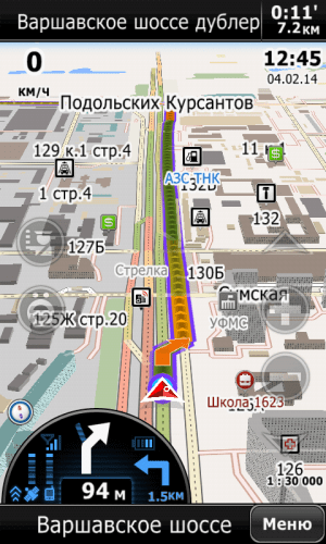
No. 1 – Yandex Navigator

The main features of this program are:
- Ability to plan a route taking into account traffic jams;
- Voice prompts, including in the background;
- Reflection of traffic events and even house plans;
- Demonstration of the current speed, distance to the target and the expected time it will take for the route;
- Option to search nearby for necessary facilities, such as restaurants, cinemas, gas stations;
- Work online and offline;
- Constant traffic updates in real time;
- Travel history;
- Reflection of data on permitted free and paid parking spaces;
- Hints that a parking space has become available;
- Adding your own comments to places or routes;
- Markings on maps – information about road accidents and road repairs;
- Satellite view.
For the modern user, there are many high-quality navigators to choose from. The functionality of each program is different, but each of them is able to satisfy basic needs when moving around a large city or an unfamiliar place. Which navigator is better to install on Android - the decision is up to you.
If you are reading this, it means you were interested, so please subscribe to our channel on , and for one thing, give it a like (thumbs up) for your efforts. Thank you!
Subscribe to our Telegram @mxsmart.
Many car enthusiasts now use navigators. Such devices are especially in demand on long trips, in unfamiliar cities or places. Currently, stores offer a wide range of GPS navigators, but most of them do not meet the requirements that are important for normal navigation in a car. Is it really necessary to purchase a navigator? Can a device running Android OS be used in this capacity?
So, let’s assume that you have a tablet or smartphone, because now rarely anyone can do without them. And if the gadget has a GPS module, then you have an excellent navigator in your hands. In most cases, it will work much better and more reliably than GPS routers on the market.
Navigator for Android is special application, capable of performing address searches and plotting the most optimal route, taking into account the type of transport, traffic jams and road repairs.
Today at Google Play You can find a huge number of free navigators for your Android smartphone or tablet. But which one is better to choose? We tried to make your search easier and collected the ten most popular navigators.
Pros of a navigator on Android
List of main advantages:
- Operation speed- majority android devices have powerful processors, so their speed will be an order of magnitude higher than that of navigators.
- Functionality - functionality tablet and smartphone are much wider. With their help, you can not only visually monitor the map of the area, but also receive information about traffic jams, talk on Skype, and use other Internet capabilities.
- Battery power- the presence of a capacious battery allows the gadget to work in offline mode from 6 hours or more. But the navigator battery will, at best, last you 30 minutes of operation.
- Big screen- it is much more convenient to watch the map on it than on the screen of a miniature navigator.
- Software Update- Navigators are often equipped with firmware, which is very problematic to replace with more recent ones. On Android there is no navigation firmware at all. She simply isn't needed there. All you have to do is download the APK, run the installer, and you’re good to go. If you wish, you can update the map version in a couple of minutes and load other maps.
Disadvantages of a navigator on Android
Are there any downsides to using your phone as a car GPS navigator? There are, and we will list them now:
- Screen size- a large screen, it turns out, can be both a plus and a minus. The fact is that if the tablet is large, then it is problematic to place it on the front panel. This requires special fastenings. If you just put the tablet on the next seat, it will be inconvenient to use.
- Price- the cost of a tablet is higher than the cost of an average navigator. And to acquire cheap phone risky. It may have a weak processor or no GPS module. However, there is a way out here too. You can purchase a tablet separately, and external module GPS. In terms of its parameters, such a module is superior to its built-in analogues. True, the external module drains the tablet's battery, but it can always be recharged from a car battery.
- GPS module- on tablets that are not very well made well-known companies, there are weak GPS modules, inferior in sensitivity to navigator modules. The exception is devices manufactured by well-known companies. Everything is fine with their modules, the quality of the equipment is excellent.
Installing a navigation program on Android is not difficult. You can download it from Google Play, and then just run it as a regular application. A new icon will appear on the gadget's desktop.

The best navigators for Android

 1. Yandex Navigator– An excellent application that will show you how to get to your destination without traffic jams so that the journey takes less time.
The navigator calculates how best to get from the start to the destination, taking into account traffic jams and road events - accidents and other accidents, repairs and road closures. There are up to three travel options to choose from, starting with the fastest. If the route passes through a toll section, the application will warn you about this.
DOWNLOAD YANDEX NAVIGATOR

 2. Navigator– the second most popular application, with more than 5 million downloads worldwide. The application will help all users quickly open and use popular maps with GPS navigation. Open navigation on your phone in one click.
The program size is only 4.6 M and it is available for free download on Google Play.
DOWNLOAD FROM GOOGLE PLAY
is a free detailed GPS navigation app that uses OpenStreetMap data. The application works on most Android smartphones and tablets. Maps are installed on the device's internal memory or SD memory card in advance, so that there is no need to connect to the Internet while traveling. Maps and the application are updated once a month completely free of charge.
DOWNLOAD MAPFACTOR

 4. Navitel GPS & Maps– accurate offline GPS navigation, geosocial services and detailed maps of more than 60 countries. The application has already been installed by more than 20 million people around the world.
Among the advantages it is worth noting:
- GPS/GLONASS.
- Offline maps support.
- Information about traffic jams.
- 3D cartography of interchanges.
- Multilingual voice prompts.
DOWNLOAD NAVITEL
 5. 2GIS: companies, map and navigator– a popular reference book with a map and navigator. The application works without the Internet - download the city database and use it on the plane, metro or roaming.
Features and benefits:
- Convenient navigation.
- Database of cities in Russia, Ukraine, Kazakhstan and other CIS countries, as well as Cyprus, Czech Republic, Chile and the UAE.
- Shopping center plans. Shows everything: from shops and cafes to ATMs and toilets.
- Data about services, addresses, opening hours and companies.
DOWNLOAD 2GIS

 6. Navigator Seven Roads– Another good navigation program called “Seven Roads”. The application supports offline openstreetmaps (OSM maps) and is capable of plotting routes longer than 10,000 km. You can always easily customize your navigator as you wish. Add-ons are ready to be downloaded from the program at any time.
Main features:
- GPS and Glonass (GLONASS).
- Offline maps support.
- Ability to create your own cards.
- HUD mode.
- Huge selection additional extensions(maps, skins, languages, voices, translations, etc.)
DOWNLOAD 7 ROADS
 7. Waze is a large navigation application that is supported on a public basis. You can also join the Russian driver community and share information about traffic situations and save time and money on your daily trips.
Simply by traveling with the Waze app, you help keep road and traffic information up to date. You can also send reports about accidents, dangers, police and other events, as well as receive this information from others, including prices at gas stations. In addition, you can add friends, share your arrival time and trip.
DOWNLOAD WAZE
 8. Navigator with traffic jams bGEO– a good hybrid GPS navigator with traffic jams, working without the Internet. BGEO combines all the advantages of offline navigation and online applications. The navigator uses compact City Guide and OSM maps for its work.
BGEO operates under conditions bad connection, since all downloaded maps are automatically cached on your device. If there is no access to the Internet, the program automatically switches to offline mode and starts working as a standalone GPS navigator.
Using the service is very simple - download, launch and get directions. The necessary data for maps and traffic jams are downloaded automatically and will be used in the future when planning a route.
DOWNLOAD bGEO

 9. GPS Navigation Sygic – popular app offline GPS navigation based on TomTom maps. With the Sygic app you can always use offline maps without the Internet, information about attractions, route planning and free map updates for free. Cards High Quality from TomTom and other providers are stored in your phone's memory or SD card so you can use them without an Internet connection.
To use all the features of the app, you need to upgrade to the premium version and get access to 3D maps, navigation with detailed voice instructions, routing with lane change commands, speed limit warnings and information about exits at intersections.
DOWNLOAD SYGIC
– Travel around the globe or view the area around you with a simple swipe of your finger using the My Maps Android app. Find your location or search by address and get to your destination using Google Maps or Open Street Map (OSM).
Navigators on Android allow you to receive accurate location information and plot routes taking into account all kinds of obstacles. Such software is most in demand when traveling through unfamiliar areas, where it is quite difficult to navigate without tips. Although some may find it useful for short walks or bike rides. If you have a car and an Android smartphone, then with a 90% chance you also have a navigation application. This article will help you choose a worthy alternative to the navigator you are already using, or choose the best navigator for you that suits all your needs.
Android smartphone with installed navigator- better than a separate GPS navigator
The GPS navigator can be purchased as a separate device, but this solution has a number of significant shortcomings. Why buy another device when the same functionality is available through an application on Google Play? Moreover, smartphones and tablets are much more productive than GPS navigators, which affects the speed of operation. Most often they differ significantly in volume random access memory, processor power, etc. It is also worth noting the situation with updates - on GPS navigators this may require periodic firmware changes, which is not very convenient. On your smartphone you just need to download new version applications from Google Play or ours.
When choosing a navigator for Android, you should be guided by which country you plan to use it in most often and for what purposes. Some applications are better adapted for use in Russia, but at the same time there are also programs aimed at Western users. They are also available on the territory of the Russian Federation, but do not contain such detailed information about it.
For comparative review 10 navigation programs from Google Play were selected, which will be considered in descending order of their popularity. When assigning ratings, we took into account not only the convenience and set of functions, but also a number of secondary parameters characteristic of applications of this type. The presence of a 3D mode, traffic data, offline access and a number of other characteristics were taken into account. A comparative table with editorial ratings is located at the end of this article.
The Google application is a confident leader in its segment, significantly ahead of its competitors in terms of the number of installations. This is due not only to the fact that the developer integrates its own services into Android, but also to significant changes that have occurred over the past few years. During this time, the number of supported countries has increased and the functionality has expanded significantly. But first things first.
There are no questions about the appearance of the application; everything is in perfect order. Most of the screen is occupied by a map; at the top there is a search bar, where you can access and voice input. You can find not only a place by address, but also a store or restaurant, knowing only its name. The main menu opens by swiping from the left edge and contains almost everything you need - a list of saved places, chronology, traffic data, etc. When you first start, you will need to connect using a Google account, in the future all statistics will be stored on it. You can leave reviews about the establishments you visit directly from the application.
The functionality of Google Maps is truly comprehensive - the user can not only plot routes, but also plan visits to certain establishments. Each of them has a rating with reviews from visitors, be it a cinema, pharmacy or clinic. For some there is also more detailed information - operating hours, workload, etc. The journey will take less time if you choose the optimal route taking into account traffic jams and public transport schedules.
IN mobile version Google Maps offers the well-known Street View, designed to view locations in 3D mode. Not long ago, an offline mode appeared, allowing you to receive data without access to the Internet. To use the map without connecting to the network, you need to open the Offline maps item in the main menu and select the required area there. Depending on its size, the size of the downloaded package will be determined. For example, for Moscow it is about 160 MB. Cities with a population of over a million “weigh” about 30-50 mb. It is worth remembering that it is still advisable to constantly have access to the Internet. You can get directions without it, but you won’t be able to view data about establishments.
Google Maps can be considered an absolutely deserved leader among navigators on Android. At the time of writing the review, the application contained maps of 220 countries, 15,000 cities with driving directions and detailed descriptions more than 100,000 establishments. Most of the functions are available in the Russian Federation, the maps are quite accurate, and there are more than enough reviews about different places from Russian users. Google maps can become an indispensable assistant both for navigation in your home region and for trips abroad. Unlike most competitors, the application is completely free; you only have to pay for Internet traffic. The final score is 4.9 points out of 5.
Waze can be considered one of the main competitors of Google Maps. In some respects, this application is significantly ahead of its famous competitor - social interaction is better organized here and more data is presented about the situation on the roads, police checkpoints, accidents, etc. The detail of the maps depends on the region - the larger the settlement, the more detailed the information about it.
The Waze interface is quite convenient, and the appearance is not for everyone - visually it is made in the style of 2010. When starting, you should register, although this is not necessary, it’s still worth creating an account - it’s available to authorized users more features. The main screen contains a map and a search bar, and you can call up the main menu by swiping from the left edge - here the user has access to account information, settings, travel plans, etc.
The functionality of the navigator in Waze does not stand out much from its competitors - you can select the current route taking into account the traffic conditions, find the cheapest gas station along the way, etc. Also available voice prompts\search and 3D review. The detail of the maps is quite good and the application is quite suitable for use in the CIS countries.
Waze can be considered a very worthy alternative to Google Maps. It is unlikely that the developers of this application are able to catch up with their main competitor in terms of the number of countries supported, but in terms of social interaction, everything is done perfectly. Waze supports dozens different languages, including Russian, in which not only voice input is available, but also hints. There is also an offline mode and not paid content, however there are advertisements. Overall, Waze gets 4.8 points.
Sygic is one of the most advanced navigation apps on Android. In his arsenal a large number of maps from various providers, including offline 3D maps from TomTom, relevant for more than 120 countries.
Visually, Sygic looks quite decent, and there are no questions about the ease of control. Some users may find the fonts in the application too large and cannot be changed in the settings. In general, the Sygic interface is quite similar to a regular navigator - most of the screen is occupied by a map, it also has a search bar and a quick menu.
One of key advantages Sygic are high quality maps that can be stored on your device. In addition to the aforementioned TomTom, other providers are available. Free map updates occur several times a year. The application supports voice commands with pronunciation of street names and receives information about changes on the road in real time. This allows you to avoid traffic jams and use the most optimal routes.
Sygic is a very high quality navigation app with lots of maps and a wide range of features. Unfortunately, not everything is available in the free version. The trial period is 7 days, after which you can limit yourself to free functionality or upgrade to Premium. The cost of a subscription depends on the region and ranges from 50 to 100 euros, but at the time of writing the review there were discounts and you could get unlimited Premium for only 16-20 euros. Given the availability of very decent free navigators, most users will not pay for a subscription. Moreover, the free version is not particularly limited in terms of map detail. The final score for Sygic is 4.6 out of 5.
MapFactor is a navigator using Open Street Map data. Maps can be installed on a memory card or internal storage of the device so as not to connect to the network during a trip.
When you first start, you need to select the map source and country. For Russia, there is a division by region, which allows you to save space in the device’s memory and quickly access the application. The cards are relatively compact, for example, the Moscow region weighs only 0.3 GB. If you wish, you can use data from TomTom instead of Open Street Maps. Externally, MapFactor looks somewhat outdated - the interface is more similar to applications for Android 2.2.
Open Street Map is a collaborative project for creating maps. Any user can contribute to its development. Having a large international community has a positive effect on the quality of content and frequency of updates.
MapFactor supports voice navigation, route planning, and alerts about upcoming maneuvers. If you get close to the speed recorders, the user will hear an audible warning. Implemented not only switching between 2D and 3D modes, but also selecting color scheme– day or night.
MapFactor can be called one of the best free navigators on Android. It supports many languages and contains detailed information for dozens of countries. The disadvantages of the application include a somewhat outdated interface and the need to preload maps. The final MapFactor score is 4.4 points out of 5 possible.
MAPS.ME – free and completely offline maps. The Android app supports turn-by-turn navigation and is used by more than 60 million users worldwide.
Externally, MAPS.ME is not much different from other navigators. Most of the main screen here is occupied by the map, and closer to the edges of the display there are control elements - zooming, toolbar, etc. In general, the controls are quite convenient.
The main advantages of MAPS.ME are autonomy and the absence of paid content. Maps are downloaded directly from the application, just select the country and city. The information on them is quite detailed - the user can easily find the way to any establishment. Maps are updated daily by the multimillion-strong Open Street Map community, which is a worthy open-source alternative Google Maps.
MAPS.ME is one of the best mobile navigators based on Open Street Map. The Android application has a pleasant interface and a large range of tools, and there is no charge for its use. The final MAPS.ME score is 4.6 points out of 5.
2GIS is one of the most popular navigators in Russia. This application has been in great demand for a long time - ever since Mobile Internet was expensive and slow, and cards were most often used offline.
The Android version has a user-friendly interface, although it doesn’t stand out much from its competitors. Main screen consists of familiar elements - maps and control panels. It is not necessary to create an account in the application, but it can still be useful for better integration with social networks.
2GIS is convenient primarily because it works without the Internet. After downloading a city map, you can use it in roaming or in places where there is no network connection. 2GIS not only knows the roads and landscape structure well, but also has information about various establishments that the user may need. These include clinics, post offices, cafes, car services and much more. Now you don’t even have to look for the front entrance - the application will do it for you, showing the way to the door itself. In total, the database contains more than 2.5 million different organizations.
2GIS will be an indispensable assistant for drivers. The application will show the most optimal route and warn about all dangerous maneuvers. Traffic jams, overlaps, accidents and other obstacles are also taken into account. The detail of the maps depends on the location. 2GIS is available in all major Russian cities, some of them contain detailed information about shopping centers, that is, you can see directly from the application where the nearest ATM is located, which stores are present in the shopping center, etc.
2GIS has proven itself well for a long time and the Android version is no exception. Here the user will find all the necessary navigation tools, and completely free. There is no charge for using the application, but there are advertisements. 2GIS gets 4.7 points out of 5.
Yandex.Navigator will help you quickly get to your destination by calculating the optimal route taking into account traffic jams. Other road events are also taken into account - accidents, repairs, etc.
The application has a very convenient and stylish interface, although nothing else was expected from Yandex. By default, the main screen shows not only the map and standard panel tools, but also an indicator of traffic congestion on a 10-point scale (for those cities where information about traffic jams is available).
When selecting a route, several options are offered, starting with the fastest. The application will notify the user if part of the route falls on a toll section. During your ride, the remaining time and distance are displayed, as well as notifications about maneuvers, cameras and other obstacles. Yandex.Navigator has data on speed limits; if the user is driving too fast, he will receive a corresponding notification.
Control in Yandex.Navigator is quite convenient, especially since you can completely switch to voice input. This will allow you not to touch the device with your hands at all during the trip. The user will be able to give commands by voice and receive all necessary notifications in the same mode.
You can save a history of destinations so you don't have to enter an address each time, but simply select a destination from a list in the future. Data is stored in the cloud and is available on all devices. For this you will need a Yandex account.
Otherwise, this navigator has a standard set of functions. There is a 3D mode and data about various organizations that you may encounter along the way - hospitals, restaurants and much more. The application is intended primarily for the CIS countries, which is reflected in the detail of the maps - for the cities of Russia, Ukraine, etc. there is much more information here. For example, Yandex.Navigator knows everything about Moscow parking lots up to the 3rd transport ring. The application will immediately show you where you can leave your car and where it is prohibited to park.
For users from Russia, Yandex.Navigator will be the best option. Everyone is present here necessary functions, including offline mode, while the program is completely free. The final score is 4.8 points.
Navitel Navigator is an application with detailed maps more than 60 countries. In essence, this is a full-fledged navigation service with a huge number of additional functions, but first things first.
Visually, Navitel Navigator looks like an application from 2010; for some reason it even has its own status bar with current time, battery charge, etc. You can immediately see from the fonts and size of some icons that the developers were focused on screens with low resolution - in FullHD it all looks ridiculous.
Functionally, Navitel Navigator can be called one of the most advanced applications in its segment. There are offline maps, data on traffic jams, weather and various road events. There are also warnings about video cameras, accidents, etc. Three-dimensional maps display not only the structure of the landscape, but also the height of buildings. Multi-level interchanges are also available in 3D mode.
In terms of map detail, Navitel Navigator is ahead of most competitors. When laying routes, many factors are taken into account, including road lanes, and on-board computer displays data from more than 100 different sensors - time, speed, weather etc. The advantages of the application can be listed for a very long time - they include voice prompts and an unlimited number of points when constructing a trajectory and much more.
Navitel Navigator would be among the leaders in its segment if not for a paid subscription. The trial period is only one week, after which the carriage turns into a pumpkin. In our case, a significant number of functions are simply disabled - route planning, voice prompts, traffic jams, 3D mode. The premium version costs between $10 and $30 depending on the country. At the same time, there are no maps of most of Europe and America here at all. In total, Navitel Navigator receives only 4.3 points out of 5.
CityGuide is a navigator with detailed maps of the whole world. You can use both data from the CityGuide service and Open Street Maps.
CityGuide looks pretty good (although it lags behind competitors by about 5 years in design) and with controls special problems not visible. At the first start, the user chooses which cards he needs. The CityGID system is paid and more detailed. Maps from Open Street Maps are completely free, but they are updated less frequently and contain less information.
The functionality of CityGuide does not particularly depend on which system the user chooses - CityGuide or OSM. In both cases, he will have access to traffic data and offline navigation. At the same time, CityGID has a number of advantages - in addition to the above-mentioned frequency of updates, these include warnings about traffic police radars and various hazards on the roads, as well as taking into account the schedule of railway crossings and opening/closing of bridges.
In general, CityGuide is designed primarily for the CityGID system; OSM support is more like an additional feature. option. This is far from the only application that works with Open Street Maps. CityGuide also has social interaction features, where you can send messages to friends and plan trips together. An SOS service is also available, allowing you to call a tow truck or various emergency services.
CityGuide can hardly be considered a worthy alternative to other mobile navigators. This is primarily due to the paid subscription model. After the 15-day trial period ends, the application stops running altogether. That is, there is not even a limited free version. Purchasing a license will cost 690 rubles for home region or 1490 rubles for all of Russia. There are other options, which can be found on the official website of the application. CityGuide rating – 4 points exactly.
Maverick is the most modest of the 10 navigators selected for this review. Essentially this is not independent service, and the shell supports various offline and online maps.
In terms of design, Maverick was stuck somewhere in 2010-2012, although this common problem for navigation applications. When you first launch it, it immediately becomes clear that the developers were focusing on low-resolution screens that were popular 5 or more years ago. And the Russian language is not supported here.
The main advantage of the application is the ability to choose a data source - Bing, Yandex, Open Street Maps, Multimap and many others. Most maps are automatically cached for offline use.
In Maverick, the user can build routes, mark places visited, and receive information about establishments. Also available are speed sensors, altitude sensors, barometer and much more.
The disadvantages of Maverick include not the most user-friendly interface and the presence of significant limitations in the free version. It does not allow you to download maps or save routes. There is also no integration with Foursquare. True, the Pro version is quite inexpensive - 300 rubles. However, for most users this program is useless if there are more worthy free analogues. Overall, Maverick gets only 3.9 points out of 5 possible.
Results and comparison
Among the navigators selected for review, the leaders, as expected, were applications from Google and Yandex; Waze also performed well. The selection turned out to be of quite high quality and it is difficult to identify obvious outsiders. These included several applications with an inconvenient paid subscription system that imposes significant restrictions on those users who do not purchase it.
In addition to Google Maps and Yandex.Navigator, Waze entered the top three
The Google application received 4.9 points, the other two - 4.8. It is unlikely that such a ranking will surprise anyone. Google Maps is the reference navigator by which developers of other applications are compared. Most of the participants in this review received ratings from 4.3 to 4.7. Only CityGuide and Maverick are left far behind - the first due to the lack of a free version as such, the second due to limited functionality.

Evaluation of additional features
By comparative table No. 2, you can see that in three out of five indicators, all 10 navigators are not much different. Each of them supports route planning, 3D mode and provides offline access to maps. How well each of these functions is implemented can be judged by general assessments.Traffic data is provided by 7 out of 10 applications, but in terms of the presence of paid content, the applications are divided in a ratio of 60 to 40. Only 4 navigators have paid subscription or cards, and they were not included in the top three. Paid navigators are almost in no way superior to free ones, and in many ways they are even inferior, while developers also want to make money from them. Perhaps there are countries in which Maverick or Sygic are superior in detail to the same Yandex.Navigator, but when compiling the final rating, the situation in Russia was taken into account primarily.

Applications from Yandex or Google have been occupying first places in the top of certain segments for a long time and this will not surprise anyone. A similar phenomenon can be observed among dictionaries (Google.Translate and Yandex.Translator), music programs, browsers, etc. Navigators are no exception, here applications from Google and Yandex also took the top. A worthy alternative is Waze, which is significantly superior in terms of tools for social interaction. Other applications in this review They cope with their tasks well, but in the opinion of the editors they cannot yet compete significantly with the above three leaders.
Here is the final part of the “series” about popular car navigation applications for Android. In it we tried to summarize all the information from five previously published reviews individual applications and give a final assessment. In order not to burden the reader, we will try to do this in the most concise and clear form using tables, providing them with relatively small comments.
Why did you choose these particular applications? The main criteria were popularity and the presence of a large number of positive reviews, as well as ease of use. The updated Shturmann did not fit into the first two criteria a little. The “Seven Roads” application did not pass all three criteria. Google Maps as a navigator is still in beta testing. Megafon navigation is essentially the same as Progorod, but only in an online version. The iGO app has not yet officially appeared in the Android version. Therefore, there are only five participants.
Prices and popularity
Putting ourselves in the buyer’s shoes, let’s start by looking at price tags and studying information about how popular a particular product has gained among users.
| Navitel | Progorod | Sygic | CityGuide | Yandex | |
| number of downloads on Google Play, million | 5-10 | 0,1-0,5 | 10-50 | 1-5 | 5-10 |
| rating on Google Play | 4,1 | 4,2 | 4,2 | 4,1 | 4,2 |
| price of Russian cards | 1350 rub. | 1290 (950*) rub. | €40 | 1800 rub. | for free |
| minimum price | $1** | - | €20 | 990 rub. | for free |
| update fee, rub | for free | for free | for free | for free | for free |
| traffic jam service fee, rub | for free | for free | does not work in Russia*** | for free | for free |
| allowed number of reinstallations | 1 | 3 | n.d. | 3 | not limited |
| free third party maps | Yes | Yes | No | Yes | No |
| test period, days | 30 | 30 | 7 | 15 | - |
* if you purchase a key on the developer’s website. The price is for the application itself with unlimited access to maps.
** rental of foreign cards.
*** for Europe the service is paid - from 12 euros per year.
So, the most expensive product is Sygic. It is aimed at European consumers, so the price tag is quite appropriate. In addition, you will have to pay separately for traffic jams and advanced information about cameras, but this all applies only to Europe. Network services do not work in Russia.
The prices of Navitel and Progorod seem to be the most adequate. However, Navitel has a very strict policy regarding reinstallation. Transferring the application to another smartphone will most likely not work at all.
Against the backdrop of all these restrictions, Yandex looks like a king. However, the application has a number of significant limitations, thereby leaving good chances for others.
Feature Set Comparison
The developers of most of the presented applications are trying to attract users with various additional functions, for example, weather, photos on a map, articles from encyclopedias, tagging in social networks, displaying the location of friends and even augmented reality.
We have summarized the entire core set of functions of all five applications in one table:
| Navitel | Progorod | Sygic | CityGuide | Yandex | |
| Interface | |||||
| Manual map zoom during navigation | Yes | Yes | Yes | Yes | Yes |
| Battery/satellite/GSM indicators | Yes Yes Yes | yes / yes / no | in the menu / in the menu / not | Yes Yes Yes | OS status bar |
| Changing the map orientation | Yes | Yes | Yes | Yes | Yes |
| Manual map rotation | Yes | Yes | No | No | Yes |
| Mileage information | Yes | Yes | Yes | Yes | No |
| Satellite View Screen | Yes | Yes | No | No | No |
| 3D mode | Yes | Yes | Yes | Yes | Yes |
| Map tilt | only in 3D | Yes | Yes | Yes | Yes |
| Panel quick access | DPOI only | Yes | Yes | Yes | DPOI only |
| "Trip computer" | Yes | No | Yes | Yes | No |
| Night mode | Yes | Yes | Yes | Yes | Yes |
| Augmented Reality | No | Yes | No | No | No |
| Search | |||||
| Universal | No | No | Yes | No | Yes |
| Address | Yes | Yes | Yes | Yes | No |
| By coordinates | Yes | Yes | Yes | Yes | No |
| POI around / at the point / at the finish | Yes Yes Yes | Yes Yes Yes | Yes Yes Yes | Yes Yes Yes | Yes Yes Yes |
| Voice input | No | No | No | No | Yes |
| Working with routes | |||||
| Save/Load | Yes | Yes | Yes | Yes | No |
| Simulation of driving along the route | Yes | Yes | Yes | Yes | No |
| Full display | Yes | Yes | Yes | Yes | Yes |
| Working with tracks | Yes | Yes | No | Yes | No |
| Operating modes: passenger car / truck / pedestrian | Yes Yes Yes | yes / no / no | yes / no / yes | yes / no / yes | yes / no / no |
| Cards | |||||
| Map update | Yes | Yes | Yes | Yes | Yes |
| Provider | n.d. | own | Navteq | many, different | Navteq, Scanex, etc. |
| Installation of third-party and free cards | Yes | yes, based on OSM | No | yes, based on OSM | No |
| Online services | |||||
| Traffic display | Yes | Yes | No * | Yes | Yes |
| Dynamic POIs | Yes | Yes | Yes | Yes | Yes |
| Friends on the map | Yes | No | Yes | Yes | No |
| Thematic news feeds | No | No | No | Yes | No |
| Photo on the map | No | No | yes (Panoramio) | No | No |
| Weather | Yes | No | No | No | No |
| Ban on Internet access | Yes | by disabling the traffic jam service | No | Yes | No |
* only for European countries for a fee
This table is intended for self-study. Here everyone must answer the question for themselves whether this or that program has a minimum sufficient set of functions. For example, some people definitely need to work with tracks, while others need to install free OSM maps. Some applications also have extraordinary abilities. For example, displaying on a map photos of places taken by Panoramio users (from Sygic), or an augmented reality mode (Progorod), as well as speech recognition and voice commands(Yandex.Navigator).
The applications also have major flaws. Thus, Sygic does not have a function for displaying traffic (traffic jams), and Yandex.Navigator will not work fully in the absence of an Internet connection.
Interface
Since each of us has our own ideas about beauty, we will not talk much about which program’s interface is more beautiful. Our eyes found the “picture” of Navitel Navigator, Progorod and Yandex more pleasant. But this does not mean that the other two programs have any problems with their “appearance”. They're all good. These just stand out a little from the general background.
But if you step back from looking at the “pictures,” then completely different properties of interfaces come to the fore - practicality and information content. The first of them is when you always feel at ease. All you need is a quick glance at the screen to get as much information as you need. A not very good example of practicality is the interface of the same Navitel - a jumble of thin lines and small details makes it difficult to read information while driving. Practicality also includes ease of operation with menus and search.
By information content we mean displaying various related information on the screen, such as the speed limit in a given area, information about cameras, etc. The presence of all kinds of tips and additional information in the POI database.
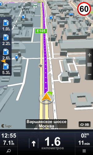
So, below we will provide screenshots of the interfaces of all programs with a short list of the main advantages and disadvantages. This time we will use a smartphone with a small screen resolution of 480x800, which is regulated by almost all software developers in today's test.
Let's start with the vertical map display option, which is the most natural for smartphones and more practical for navigation. Next to the usual map view we will place a 3D version.
Navitel Navigator 8.5

Progorod 2.0


Sygic 13.4

CityGuide 7.8

Yandex.Navigator 1.5


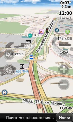
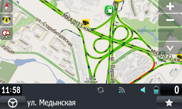
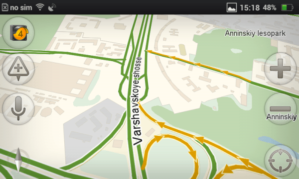
This is the junction of the Warsaw Highway and the Moscow Ring Road. Alas, the picture is static, and its perception while moving, when the scale of the map is constantly changing depending on the speed and upcoming events (turns), is radically different from what you will get simply by contemplating these two sets of screenshots. In addition, in 3D mode a lot depends on the tilt angle, which is adjustable in all programs. The developers have made it so that from one angle the map is beautiful and practical, but from another it is inconvenient to use, because the detail, perspective, etc. change. A similar remark can be made about scale. Therefore, we will give a verbal comment, but first we will post another portion of screenshots taken in navigation mode:
Navitel Navigator 8.5
Progorod 2.0
Sygic 13.4

CityGuide 7.8

Yandex.Navigator 1.5


Navitel Navigator
The picture deserves all the praise, but it is extremely impractical. The accumulation of a mass of small lines and contours makes it difficult to perceive the route line on the screen, which is slightly thicker than the road itself, but with busy traffic jams is in no way different from it in color. Camera icons, signs and other details are barely visible on the screen.
Progorod
The “Picture” is a little similar to Navitel, but there are fewer small details, and the route line is much easier to read than in the previous case. There are two complaints: the status panel takes up a lot of space on the screen and chaos reigns on it, as well as the graphics and all the control buttons are too small.
Sygic
In the screenshots, the interface is unimpressive, but from the point of view of ease of reading information while driving, it deserves the highest rating. There is one significant drawback - house numbers are not displayed in navigation mode. They only appear if you try to scroll the map in one of the directions, which will switch it to viewing mode.
CityGuide
The map interface is quite good in practical terms. It may not be as beautiful, but it is quite comfortable.
Yandex.Navigator
Trying to find fault with the Yandex.Navigator interface did not work out well. He is very practical. The only issue is that users of platforms with screens with a high pixel density per inch complain about small buttons and other elements in the menu. For some reason these UI elements don't fully match Google recommendations for developers, and programmers operated in absolute units of element sizes instead of relative DP and SP.
Well, for those who for some reason prefer horizontal position maps, we'll post another set of screenshots.
Navitel Navigator 8.5


Progorod 2.0

Sygic 13.4


CityGuide 7.8


Yandex.Navigator 1.5

Cards
Alas, most developers do not indicate detailed information about your cards, since compared to competitors they may not look so brilliant.
We tried to collect as much information as possible and summarize it in one table. Pay attention to the line “Map online” - this is your chance to independently evaluate the quality of coverage. True, it also does not entirely accurately reflect the situation. Navitel and Progorod do not have the latest release online, while Yandex’s maps in the app and online are strikingly different in places, which sometimes causes confusion.
| Navitel | Progorod | Sygic | Cityguide | Yandex | |
| Russia: populated areas | 149 047 | n.d. | n.d. | n.d. | ≈170 thousand |
| Russia: cities with details | 8762 | n.d. | n.d. | n.d. | n.d. |
| Road graph, km | 3 809 652 | n.d. | n.d. | n.d. | n.d. |
| POI objects | 992 163 | n.d. | n.d.* | n.d. | n.d. |
| Card capacity, MB | 1250 | 1131 | 623 | 1900 | 1910** (Moscow only) |
| date of last update | 25.10.2013 | 22.10.2013 | 12.2013 | 22.01.2014 | n.d. |
| Update frequency per year, times | 3-4 | 2 | 1-3 | 2-10*** | n.d. |
| Map online | - | - | |||
| Maps of foreign countries, pcs. | 52 | 28 (OSM) | ≈130 | 10 | 1**** |
| Information about maps on the developer's website | - | - |
*data from Foursquare is also used as POIs
** volume indicated full map Moscow
*** The map of Russia is updated almost every month, but changes in it each time concern a couple of separate areas. If we take, for example, the map of Moscow, it is updated twice a year.
**** Ukraine, Belarus and Türkiye are mentioned. There is no longer a word about Turkey in the company video, and only Ukraine appears on Google Play. However, in the list of maps for download you can find, for example, a map of Almaty.
According to the results of the 2010 census, the number of settlements in Russia was just over 153 thousand and about 20 thousand of them do not have a permanent population. Where did Yandex get 170 thousand from then? Firstly, nesting. A specific settlement always belongs to other territorial units. Secondly, the census does not take into account all types of settlements. Railway stations, winter huts, etc. may fall out of it.
So, our leaders, apparently, are Navitel and Yandex. The volume of cards is an indirect indicator. In Yandex.Navigator it has such unimaginable values because these maps contain a huge number of raster images.
As for the details, this issue is complex and requires a lot of time to study. For our own understanding, we took several settlements and looked at how things stand with this issue.
| Navitel | Progorod | Sygic | Cityguide | Yandex | |
| Olenegorsk, Murmansk region | detailed, with houses (3D) | three main streets | only the main street, with errors | detailed, with houses | three main streets |
| Bogoroditsk, Tula region | detailed, with houses | detailed, with houses (3D) | only the main street | detailed, with houses | three main streets |
| Angarsk, Irkutsk region | main road network | detailed road network | only the main street | detailed, with houses | detailed, with houses |
| Petropavlovsk-Kamchatsky | detailed, with houses | detailed road network | only the main street | point on the route | detailed, with houses |
| Astrakhan | detailed, with houses | detailed, with houses (3D) | detailed, with houses | detailed, with houses | detailed, with houses |
| Sochi | detailed, with houses | detailed, with houses (3D) | detailed road network | detailed, with houses | detailed, with houses |
| Chekhov, Moscow region | detailed, with houses | detailed, with houses (3D) | detailed, with houses | detailed, with houses | detailed, with houses |
| Tver | detailed, with houses | detailed, with houses (3D) | detailed, with houses | detailed, with houses | detailed, with houses |
| Rybinsk | detailed, with houses | detailed, with houses (3D) | detailed, with houses | detailed, with houses | detailed, with houses |
| Pechory, Pskov region. | detailed, with houses | main road network | three main streets, with errors | detailed, with outlines of houses, without addresses | three main streets |
| village Lanshino, Moscow region | part of the road network | a point on the map | detailed road network | detailed road network | main road network |
The leaders were Navitel, Progorod and Cityguide. Moreover, the maps of Progorod in almost all settlements from the table have buildings not only with corresponding contours, but also with height. Although CityGuide is good (OSM maps are used), you will have to look for maps of the regions you need in big list and download separately, which is not very convenient. For some reason, you can’t download the entire map of Russia at once. In addition, the Kamchatka Territory was not on the list.
Yandex.Navigator surprised me a little, and this considering the fact that the online browser map is beyond praise. At the same time, it is very funny that in the same Bogoroditsk you can indicate the exact address, it will be marked with a marker on the map and a route to it will be built. But the "last mile" will not be displayed correctly.
Well, Sygic doesn’t like small towns the most. He knows them only by hearsay.
The issue of map relevance is also important. Here we were guided by the map of Moscow, noting the presence of new well-known roads, overpasses and interchanges, opened in the summer-autumn period of 2013. Progorod, Cityguide and Yandex had no problems with this. Navitel had all the junctions and overpasses we were looking for, but for some reason at the intersection of Yaroslavskoe Highway and Malyginsky Proezd there was no turnaround under the overpass. But Sygic's map is at least a year old. We did not find any of the required road objects on it.
Our selection by cards: Navitel, Progorod and Cityguide.
Routes and navigation
All applications build quite adequate routes. And this is the most important thing. Navitel has some minor glitches. We described one of them in detail, but there is no reason to panic here. But it’s definitely worth reducing the sensitivity to traffic jams in its settings for residents of megacities.
To save the reader time, we will collect information on routes and navigation into one table.
| Navitel | Progorod | Sygic | Cityguide | Yandex | |
| adequacy of constructed routes | OK | OK | OK | OK | OK |
| number of alternatives | No | 2 | 1 | No | 1-2 |
| exclusion of toll roads / other settings | Yes Yes | Yes Yes | Yes Yes | Yes Yes | no no |
| logic of behavior when leaving the route | customizable | return to old route | changing lanes in detour mode | changing lanes in detour mode | |
| traffic jams on the route | Yes | Yes | No | yes, but at a short distance | Yes |
| speed warnings | Yes | Yes | Yes | Yes | No |
| camera warnings | Yes | Yes | Yes | Yes | yes, late |
| DPOI | Yes | Yes | No | Yes | Yes |
| work without an Internet connection | Yes | Yes | offline only | Yes | functions are very limited |
It will be most convenient to travel with Progorod, Cityguide and Navitel. Sygic, despite its very practical interface, works only in offline mode: no traffic jams or DPOI. In addition, his logic of behavior when the driver leaves the route is far from civilized. But there are no less problems with Yandex: it will not warn you about speeding, it will only tell you about the camera when you drive past it, and without a connection to the Internet, search and route planning will not work in the application! But before starting navigation, it will offer the user alternative route options, which can be viewed on the map and the most suitable one can be selected. Progorod can do this too, although it uses a slightly different logic. We really liked both of these features.
Our choice: Progorod and CityGuide. With some stretch - Navitel and Yandex.
Tests
We've run a series of tests to show how fast these apps will run on different mobile platforms. In a separate table we have summarized the results obtained on two systems, the main characteristics of which are as follows:
Both platforms are budget, but the tablet has a 4-core SoC, while the smartphone has a single-core SoC, but with a more modern architecture. Will there be any significant difference between them? In the table, smartphone and tablet data are separated by two vertical bars.
| Navitel | Progorod | Sygic | Cityguide | Yandex | |
| Loading time, s | 11 || 8 | 5-6 on both platforms | 6 || 3 | 12 || 9 | ≈2 in all cases |
| Satellite search time | in accordance with GPS technologies(1-2 min.) | ≈20-30 sec.** on both platforms | |||
| Route planning time, s* | 2,5-5 || 1,5-5 | 1-4 on both platforms | 12-20 || 6-15 | ≈2 in all cases | -*** |
| Utilization of computing cores in motion, % | 60 || n.d. | 70 || n.d. | 40 || 15 | 65 || 19 | 20 || n.d. |
| Smooth scrolling and zooming with traffic jams disabled | with strong jerks | with jerks | relatively smoothly | relatively smoothly | smoothly |
| Volume of network traffic on the route, MB/h | 2,5 | n.d. | - | n.d. | n.d. - 4**** |
| Volume of network traffic in a metropolis, MB/h | 4,5 | 1 | - | 1 | 3,5-6,5**** |
* the dash indicates the time of laying two routes: from the south of Moscow to the city of Olenegorsk in the Murmansk region; the second route is to Vladivostok.
** already two seconds after loading you see your approximate position on the map, determined by signals base stations and their coordinates. And after another 20-30 seconds the device “clings” to the satellites.
***routes are calculated on remote server, and the construction time depends on the quality of communication at a particular point in time. In GPRS or EDGE coverage area it may take a minute or more, but with good connection - 2-3 seconds.
**** The first digit indicates the traffic volume in the case of a pre-loaded full map of the region. The second digit indicates an empty card cache.
So, the main problem with application performance is the inability to use all available computing cores of the SoC. And although multithreading is declared by almost all developers, in practice on a 4-core system this results in one core being loaded at 100%, the second at 30%, and the other two cooling down. The only exception is Yandex. The application not only has low system resource requirements, but also active work on four cores it can show a total load of 60-70%, which indicates that someone is still able to create multi-threaded applications (benchmark developers do not count).
If we talk about the smoothness and comfort of working with the map, then Yandex, Cityguide and Sygic behave quite well, which cannot be said about Navitel and Progorod. Scrolling the map and scaling occurs with noticeable jerks, slowdowns and jerks. Moreover, if your smartphone has a resolution of 1280 pixels or more, the situation will worsen regardless of the type of SoC installed in the system.
Our choice: Yandex, CityGuide and, probably, Sygic. The latter takes a very long time to build routes, but otherwise is very smart.
Application Features
Since the competition is great, developers try to add a few highlights to their creation, and it would be a shame not to mention them.
Navitel Navigator

Progorod
Here we will only note the augmented reality mode, which will work quite well on those devices that have an orientation sensor.

Perhaps it will come in handy when traveling by car.
Sygic
Sygic tries to attract users with all sorts of useful and interesting little things: universal search, photos on the map from Panoramio, POIs from Foursquare, articles from Wikipedia (if they have a link to coordinates), a sidebar and a trip computer. All details in the corresponding .

CityGuide
Nothing unusual.
Yandex.Navigator
The main trump card is a universal search with a speech recognition system and voice commands, which works quite well.

Results
So, the most mentions marked “our choice” went to CityGuide and Progorod. Navitel, Yandex.Navigator and Sygic are lagging behind. But if we evaluate applications by their main functions (the quality of maps and the navigation process), then the following three leaders emerge before us: Progorod, CityGuide and Navitel. The cheapest of them is Progorod. The most expensive is CityGuide. And Navitel will receive the title of the most unfriendly due to the impossibility of transferring the application to other smartphones.
If you live in one of the Russian megacities, there is reliable and high-quality cellular If you are not afraid of speed cameras and prefer not to spend extra money, then you can use Yandex.Navigator. It's free. Moreover, it works quickly and has a practical interface.
Sygic can be useful when traveling abroad. However, it will not be cheap at all. In this regard, Navitel is many times more attractive, but it will not contain information about traffic. Just like Sygic in Russia.
P.S. Better to see once than hear a hundred times. That’s why we encourage you to try out the apps you like and make your own own conclusions. But it is important not to forget that everything navigation programs without exception, after deleting them through the application manager, they leave almost all their files in internal memory phone forever, “freezing” hundreds of useful megabytes. Don’t forget to delete them manually later, based on the names of the folders on the drive. Oh, Android, Android...
GPS navigation is one of the most popular features on a smartphone. When exploring a city by car or bicycle, it is essential to follow the best route. Navigators will help you optimize your car and get to the desired coordinates faster.
We compared popular, top mobile navigators. Main criteria: ease of use, functionality and price (free) of the navigator. At the end of the review, we will summarize: which navigator is the best.
Participants:
Over time, the review will be updated with new GPS programs. If, in your opinion, there are more interesting navigators for Android, leave your comments at the end of the article, through the contact form. Thank you!
Google Maps for Android - standard Android navigator
Reviewing Google Maps a year ago, we noted that some functions of the navigator were not finalized or optimized. By 2019, the situation had improved markedly – especially in terms of user experience. However, we note some of the rough edges of Google Maps.
The function of downloading offline maps appeared relatively recently. It allows you to plot routes and navigate on the map without an Internet connection. Due to the fact that offline maps are not yet a fully tested function, not everything is so smooth with it. However, like other Android navigators.
The inconvenience is that you cannot download maps for large regions of Ukraine, Russia, Belarus and other CIS countries. Only selected offline maps of large cities or regions are available. When driving outside the city limits, it is difficult for a motorist to do without online synchronization.
Disadvantages of Google Maps
1) The selection of locations and attractions in Google Maps is quite scarce: to get complete information about hotels, restaurants, shops, schools, etc. available nearby, you have to use third-party applets (Foursquare, TripAdvisor, Yandex.City).
2) No data on road accidents; You cannot add points with car accidents yourself, which would be quite useful for notifying other drivers.
3) In comparison with Yandex Navigator, there is no warning about speed control, there are no alternative voice assistants.
Advantages of Google Maps
However, Google Maps also has many positive aspects.
Yandex Navigator: navigator with voice control
The interface of the mobile version of Yandex Navigator is well structured and clear. When driving a car along a route, it displays information about the approximate time remaining to the destination and the distance to the final point. If you need to stop at a service station, gas station or car wash along the way, you can indicate on the Yandex Navigator map additional item- and the route will be optimally recalculated taking into account the intermediate point. You can turn on or off the layer displaying traffic and directions by pressing one single button with yellow signal traffic light.
The exclusive features of the navigator include the night GPS mode for Android, where the map is displayed in dark colors, without distracting the driver’s attention when driving late and prevents the eyes from getting too tired when looking at objects. By the way, the range of searchable POI objects is really impressive. Along with the already familiar restaurants, ATMs and cinemas, you can use layers to display nearby communication points, post offices, salons and many other interesting places.
Another nice feature is from your phone. Similar to Google Maps, you can search for the necessary objects on the map, request addresses on the map.
As for the program's offline operation, you can download GPS maps for Android for major settlements in Ukraine, Russia and Belarus. By turning on Yandex Navigator offline, you can view them, but plotting routes and searching for local attractions on the map is only possible if you have a network connection.
Thus, Yandex Navigator for Android leaves the most pleasant impression. The product claims to be the best free GPS navigator for Android in 2018.
Navitel: a well-designed GPS navigator for Android
Navitel Navigator is a GPS program from a leading developer in the field of navigation and creation digital cards. To purchase the cards themselves, you will have to fork out a small amount, but if you wish, you can download them for free on torrents or file hosting sites (for example, on the pda forum).
Strengths of Navitel Navigator
1) Map display options: switch between 2D and 3D modes, which will be especially useful in some situations.
2) User-friendly interface. The lion's share of branded chips is available in the top line for quick access. Choosing between night and day skins
4) Switching between satellites: under any weather conditions, the map with POI is always available.
Note. Not long ago we did something for Android, where we listed in detail all the advantages and individual “features”.
Navitel Navigator: GPS routes on the screen
5) Convenient control. When navigating along a route, managing the map is quite intuitive and simple: there is a zoom function, rotation of the map according to movement, and the ability to switch between preset profiles for any type of transport.
6) Information content. The movement is visually accompanied by information about the speed of the object, the remaining time to reach the destination, the distance of the nearest turn and audio support. In general, the navigation is well thought out and intuitive.
Well-thought-out functionality and high-quality design make the Navitel mobile application the main candidate in the “ Best gps navigator for Android.
Waze - an informative GPS navigator for Android
Waze (Free) is a free navigator for Android with opensource code.
Benefits of Waze
1) Social features integrated into Waze significantly improves driving experience. Waze users report problems on the road - be it repairs, accidents, traffic jams, traffic police posts, cameras and other “troubles”. Accordingly, other drivers are already aware of the changes. In addition to reviews, the application collects information from its own database on the server.
2) The map with routes is informative. Waze uses proven OSM maps. They are highly detailed and accurate.
3) Waze automatically reroutes if your phone crashes, the app crashes, or anything else that might interrupt your navigation. Standard Google Maps doesn't do this. Likewise, Waze makes it easy to view your route or map when needed and always returns to Automotive mode.
OsmAnd: navigation for Android in offline mode
Let's list the strengths of the OsmAnd navigator.
Pros of OsmAnd
1) Autonomy. OsmAnd is, first of all, not bad. Suitable for those who prefer to download maps to their gadget once and no longer connect to the Internet while in offline mode.
2) Cards. For navigation in OsmAnd, raster and vector maps of Open Street Maps are used, compiled by users of the service. They allow you to filter POI objects (attractions, museums, theaters, pharmacies, etc.), select a profile for the appropriate vehicle. The travel route can be optimized taking into account the shortest distance, avoiding toll roads, dirt roads, ferries, and highways.
OsmAnd is one of the best navigators for Android
3) Customizable maps. You can add objects yourself, create or edit maps. Thanks to the support of plugins, the functionality of OsmAnd is significantly expanded: for example, you can activate the OsMo live monitoring system with tracking of other gadgets using the service; add to groups; download sea and ski maps; calculate optimal distances between specified points using GPX; impose contour lines and layers of relief, which will certainly be appreciated by tourists and athletes).
4) Additional functions. All standard features for GPS navigators are also present: voice control, assistant, screen reorientation, profile switching.
Maps.me
Maps.me is a GPS navigator, popular in Russia, the USA and Germany. Characterized by high accuracy and autonomy of cards.
Strengths of Maps.me
1) The accuracy and detail of maps is perhaps the most important thing, regardless of the type of transport. This navigator will be of interest to travelers and pedestrians, since the map displays the smallest details - trails, benches, names of objects.
2) Additional layers. Maps.me displays vector maps; through layers you can also display traffic jams and a metro map.
3) Lots of settings. In the maps.me settings you can change units of measurement, scaling, view your movement history, etc. There are navigation settings, in particular, you can configure auto zoom, voice instructions, and enable the display of speed cameras.
4) Switching navigation modes. Choice of car, pedestrian, public transport, taxi and bicycle.
5) Autonomy. Offline maps downloaded from mobile device, take up little space, yet work fully, as if the Internet were present. It is clear that realtime functions will not be available, but for a pedestrian or cyclist information about traffic jams is not as important as for motorists.
Disadvantages of Maps.me
1) Limited navigation for motorists. It’s difficult to call Maps.me a perfect car navigator. At a minimum, travel routes are not always lined up correctly, not to mention the fact that the navigator does not offer alternative options.
2) There are errors. Since the maps are developed by the community, the data is not always up to date, especially for remote places and villages.
3) Quite inconvenient map display mode. Maps look very dry, scaling may not work.
Which navigator is the best as of 2019?
Each of the Android navigators, in some aspects (functions, maps) is better than its competitors and is good in its own way. Which navigator is right for you depends on your preferences and beliefs. We hope that we helped you choose the right application and it will remain on your phone.
| Navigator application | Developer | Price | Offline maps support | Traffic jams | Voice acting | Russian language |
| Google Maps | Google Inc. | for free | + | + | + | + |
| Yandex Navigator | Yandex | for free | + | + | + | + |
| Navitel Navigator | Navitel | from 1000 rub. | + | + | + | + |
| Waze | Waze navigation | for free | + | + | + | + |
| OsmAnd for Android | OsmAnd | from 6.75 $ | + | + | + | + |
Yandex Navigator It is absolutely free and has excellent functionality. It wins the category "Best navigator for Android with support for Yandex Maps."
Navitel Navigator created and supported by the most famous company, so the quality of products and technical support are at their best - both for Android OS and other mobile devices.
Navigation app Waze- certainly attracts with its openness and free cards. However, like any developing product, this navigator is not perfect. We hope the growing community will have a positive impact on the quality of the application. As of 2018, alas, Waze maps are inferior in information content to the same Navitel or Google Maps.
Concerning OsmAnd, then this offline navigator for Android will serve perfectly in conditions where it is impossible to connect mobile device to the network and works using open technologies.
Google Maps- navigator with function voice control. The good thing is that it is available out of the box (that is, it is initially included in Android). Google Maps is suitable for inexperienced travelers and drivers; it can be called one of the best offline navigators.
Maps.me will appeal to avid travelers and walkers. The navigator will delight you with detailed maps adapted for walking. We would recommend alternatives to motorists - Google Maps or Yandex Navigator.