Car tablet - GPS navigator. Tips for choosing
The versatility of a modern tablet PC is difficult to overestimate. One such device can easily replace a laptop, phone, e-book, media player, as well as a navigator, including for a car. We have made a selection of five tablets with a GPS positioning module and GLONASS support, which are able to determine the user’s position even without an Internet connection.
Differences between GPS and GLONASS
As you know, GLONASS and GPS are global navigation satellite systems, the most extensive, widespread and with the largest number of satellites in Earth orbit, almost perfect systems for determining location, speed and exact time. There are also less global services Galileo (European Union) and BeiDou (China), which are very limited in scale and are significantly inferior to the main global services.
In the segment of consumer electronics with built-in positioning modules, GPS systems and GLONASS are not considered to compete with each other for the simple reason that modern devices in most cases, they combine the capabilities of both services simultaneously. But this does not mean that each of the systems cannot work separately.
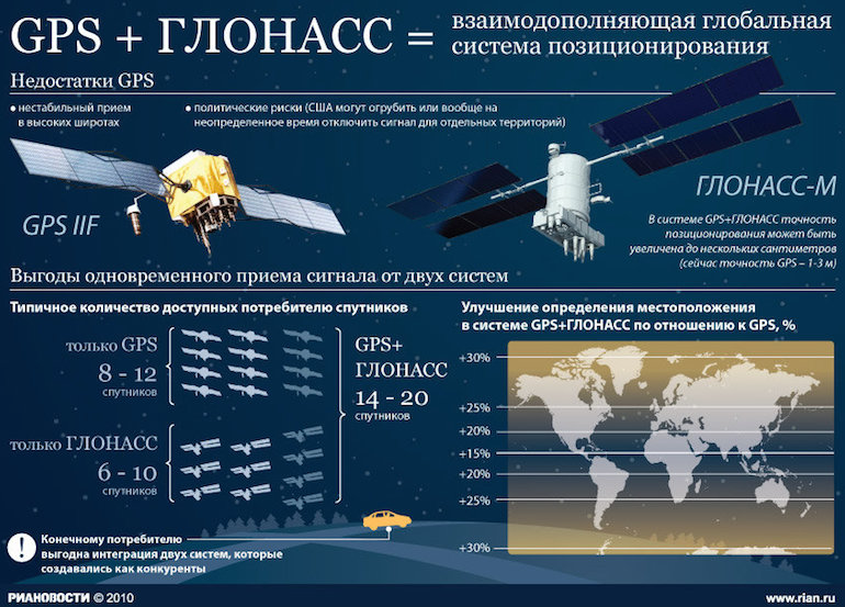
IN in this case, I want to talk about the advantages of GLONASS, which is especially relevant for the CIS countries, because it was developed back in the days of the USSR. Signals from GLONASS satellites significantly reduce initialization time and increase the reliability of the results obtained. The service is relevant when determining location in unfavorable, difficult observation conditions, such as mountainous areas, high northern and southern latitudes, high-rise building areas, because thanks to the constellation geometry factor, the user receives more accurate data. In addition, the GLONASS System, unlike GPS, allows reliable reception of the navigation signal in the areas of the south and north poles of the Earth. So in case of disconnection GPS services(NAVSTAR) or jamming the frequency of this system, you can always count on the functionality of GLONASS.
 |
 |
 |
 |
 |
| Fujitsu Stylistic M532 | Samsung Galaxy Tab 3 7.0 Lite | ASUS MEMO Pad 7 ME70C | Lenovo Tab S8-50F | Dell Venue 7 Model 3730 |
Fujitsu Stylistic M532
A very affordable but productive tablet has a stylish case with a soft-touch coating and a nice design. Stylistic M532 is equipped with a 10.1-inch matrix with a resolution of 1280 x 800 pixels, which is perfect for performing any multimedia tasks, be it surfing the web or watching movies in HD resolution. In addition, there are stereo speakers that provide loud and very high-quality sound.


The tablet is controlled by the operating room Android systems 4.0.3 s pre-installed programs and services from the developer. The NVIDIA Tegra 3 quad-core processor with a frequency of 1.3 GHz and GeForce ULP graphics are responsible for an excellent level of performance and execution of all tasks. There is also 1 GB random access memory and 32 GB of expandable storage space.

In addition, the Stylistic M532 boasts an 8 MP main camera and a 2 MP front photo module for video calling. It has modern Wi-Fi modules 802.11 b/g/n, Bluetooth 4.0 and GPS with GLONASS support. In addition, the standard modification of the device includes a 3G module for access to fast mobile internet. So, it will be possible to download maps of the area while on the road, update navigation data, and also create a post in in social networks, being far from your home Wi-Fi.

PECULIARITIES
Stylish design.
10-inch matrix.
8 MP camera.
. 3G.
Samsung Galaxy Tab 3 7.0 Lite
Having a classic Samsung design with a proprietary hardware Home button, rounded corners and a flat frame, the tablet turned out to be special thanks to the back panel, made of soft-touch plastic with a texture that imitates leather. Galaxy Tab 3 7.0 Lite turned out to be compact and light - only 310 g.

The “lightness” of the tablet also lies in its balanced, affordable equipment. It has a 7-inch screen with a resolution of 1024 x 600 pixels, a dual-core Marvell PXA986 processor with a frequency of 1.2 GHz and Vivante GC1000 graphics, 1 GB of RAM and 8 GB of expandable storage. The available performance is more than enough to read pages on the Internet and run low-demand games. Plus, navigation apps and maps are fast and smooth, perfect for travel.

The manufacturer equipped the device with a 3600 mAh battery, which can provide up to 8 hours of video viewing and up to 9 hours of web surfing. Of course there are wireless modules Wi-Fi, Bluetooth, and GPS with GLONASS support.


Galaxy Tab 3 7.0 Lite runs Android 4.2.2 operating system pre-installed graphical shell from the manufacturer.

PECULIARITIES
Compactness.
Good level of autonomy.
Balanced configuration.
ASUS MEMO Pad 7 ME70C
An affordable price does not mean that the device will have simplified functionality, a cheap appearance and low level productivity. After all, MEMO Pad 7 ME70C looks bright and modern. The tablet screen is edged with a stylish glossy frame, and the back panel is made of practical textured plastic. At the same time, the device is ergonomic, compact, convenient and lightweight - only 275 g.

The tablet uses a 7-inch screen with a resolution of 1024 x 600 pixels, which, thanks to good color reproduction and excellent brightness, will allow you to enjoy watching your favorite films and TV series. MEMO Pad 7 ME70C is built on a processor Intel Atom Z2520 in which two cores operate at a frequency of 1.2 GHz, and Intel HD Graphics is responsible for the graphics component. There is also 1 GB of RAM and 8 GB of data storage, expandable using a microSD memory card. Responsible for a good level of autonomy lithium polymer battery capacity 3220 mAh.

There are wireless modules Wi-Fi, Bluetooth and GPS with GLONASS support. There are also two cameras with a resolution of 2 MP and 0.3 MP.

In addition, the tablet runs Android 4.3 OS with the proprietary ZenUI graphical shell with many proprietary applications and improvements.

PECULIARITIES
Compactness.
Balanced platform.
Android 4.3+ZenUI.
Dell Venue 7 Model 3730
The famous American manufacturer produces not only computers, laptops, server equipment and monitors, but also great tablets, including those running Android.

Venue 7 is an affordable device with a 7-inch IPS display with a resolution of 1280 x 800 pixels, which provides clear, rich images with maximum viewing angles. A powerful dual-core processor is hidden in a practical, smooth case with a soft-touch coating. Intel processor Atom Z2560 with clock frequency 1.6 GHz and Intel graphics HD Graphics. It has 2 GB of RAM and 16 GB of data storage with expandable capacity. The tablet shows a good level of performance for any modern task.

Fixed lithium ion battery Provides about 6 hours of mixed use without recharging. There are also two cameras that are suitable for taking business cards and reading QR codes.

Of course, there are wireless modules Wi-Fi, Bluetooth and GPS with GLONASS support.

PECULIARITIES
Sleek, practical design.
IPS matrix.
Productive platform.
Lenovo Tab S8-50F
The star of this collection can rightfully be considered the Tab S8 for a number of reasons. It is stylish, well-coordinated, without unnecessary gloss but with elegant charm. The slightly rounded corners, glossy edging and front stereo speakers look nice. The back panel, in contrast to the glossy front edge, is made of soft-touch plastic, resistant to scratches and fingerprints. At the same time, the tablet is ergonomic with a body thickness of less than 8 mm and a weight of almost 300 g.

It has an 8-inch IPS screen with a resolution of 1200 x 1920 pixels, so the image is simply stunning, clear and with natural color reproduction.
The tablet uses a quad-core Intel Atom Z3745 processor with a frequency of 1.33 GHz (overclocked in Turbo Boost, frequency can reach 1.86 GHz) and Intel HD Graphics video core. The RAM capacity is 2 GB, and internal storage designed for 16 GB, expandable. Therefore, the tablet shows the highest level of performance; it is not afraid of even the most resource-intensive games and applications.

By the way, Lenovo Tab S8 is controlled by an operating system Google Android 4.4.2 Kit Kat with a proprietary graphical shell and many pre-installed applications. The installed main 8 MP photo module ensures shooting high-quality photos and Full HD. Wireless modules Wi-Fi 802.11b/g/n, Bluetooth 4.0 and GPS with support for A-GPS and GLONASS are also installed.

![]()
Modern tablet computers are complemented by navigation models by default. The vast majority of them work properly and without interruption. Enough to activate useful function, using the system settings, turn on maps and find your own location or get directions to the desired point. Can be performed by the user independently GPS setting on the tablet. How to setup?
Selecting and configuring GPS operating modes
You can and should enable the function from the notification panel. This function is called from the main menu using special button, which looks like a needle. To correctly determine the default or user-installed configuration mode, you should:
- Go from settings to personal data.
- Find the “Location” menu, and then open the “Modes” tab.
The Android operating system offers several options to choose from. This includes, in addition to battery saving, accuracy high level and by device sensors. New devices have different names of points (coordinates, sources, GPS satellites).
High accuracy allows you to quickly determine your location, but it is also the most expensive in terms of energy. Battery saving or network coordinates is a mode that involves using only a wireless network to search for roads and locations. Sensors or satellites only work in open areas with good welcome signal.
How to configure GPS on a tablet using the engineering menu?
Problems of long connection, periodic loss of satellite and network signal, incorrect work And unstable network– all this can be encountered by a user not only of cheap Chinese equipment, but also of famous manufacturers. To quickly troubleshoot and bring your tablet back to life and GPS module, you can configure it yourself engineering menu. This will require super-administrator root rights, and the user performs all actions only at his own peril and risk.
To configure the engineering menu, you should:
- Turning on wireless network WiFi, as well as a GPS module, you should go out into an open area or onto a balcony.
- Open the engineering menu. To do this, you will need to enter several key combinations: *#*#4636#*#* or *#15963#*, you can also *#*#3646633*#*#. The specific combination is selected depending on the model tablet computer. If all the suggested options are not suitable, you can download the Mobileuncle ToolHero program. She suggests the corresponding item on the menu.
- The menu that opens should be scrolled until the Location tab opens. Here you should open Location Based Service.
- The menu that opens allows you to activate the not always active Enable EPO items (suggests the coordinates of the satellites, as well as their trajectory), as well as Auto Download.
- Returning to the previous menu, you need to find the YGPS button. It will allow you to view all satellites. All those marked in red are seen by the tablet, but cannot use them due to incorrect setting networks.
- In the Information menu, click on the full button. After a few seconds of break, you should also press AGPS restart.
- In the Satellites tab, you can see how the tablet connects to satellites, after which they are highlighted in green.
After saving and rebooting the device, all satellites will be caught without problems.
In order to navigate the whole variety of car tablets and navigators, and therefore make right choice, you need to know the main technical specifications, which you need to pay attention to before purchasing.
In general, the basis of any high-quality device is its filling, regardless of the manufacturer.
A good car tablet should have:
- highly sensitive GPS receiver;
- reliable and well-proven hardware components (processor, built-in memory, etc.);
- modern and proven software (maps).
These basic parameters will determine how quickly and, most importantly, how accurately the GPS navigator will make all the necessary calculations and determine your location.
What to choose - GLONASS or GPS?
Many people are at a loss as to which system is better and what to choose for their car. The main difference between these navigation landmarks and each other is the country of origin, that is, GLONASS is Russia, and GPS is America. For our realities, the most practical and useful would be a car tablet that works with domestic navigation, or at least hybrids - GPS/GLONASS.

You should not buy devices that only support GPS navigation. Due to latest events The American government can completely turn off its system in the territory Russian Federation, and the only thing the GPS navigator will be capable of is to show the time and date.
Display
When choosing a screen size, you don’t need to go to extremes: a too small one takes up less space, but everything is hard to see on it, while a large one will block the view, although the information on it is better visible. The optimal car tablet is 7 inches or 5, depending on the front panel of the car and the frontal view.

High-quality, and therefore expensive, tablets are equipped with an IPS matrix, which provides good angular viewing, compared to cheaper analogues running on a TN matrix. As for resolution, the principle of choice is the same - the more, the better. Almost all five-inch models have a resolution of 800 by 480 pixels, and seven-inch gadgets have a resolution of 1024 by 600. For example, the Lexand SC7 Pro HD device has a resolution of 1024 x 600 pixels, and this is quite enough for a high-quality picture that you don’t have to look closely at to disassemble the details.
operating system
The best option remains the Android platform as opposed to the Windows operating system. The first has wider functionality and capabilities, and software for her, presented in a huge assortment. In addition, using third party software you can significantly improve a car tablet running on the Android platform. And device developers primarily release updates for “green” devices. operating systems, and only then for Windows.
Chipset
The chipset in the navigator is responsible for the quality of signal reception and the accuracy of coordinate determination. The Star and SiRF series chips are enviably popular and respected by specialists. One of the main advantages of these chips is the reception of reflected and weak signal with high positioning accuracy. They are indispensable in urban environments, as they allow you to “break through” the dense buildings of megacities. If you use a navigator outside the city, then you should pay attention to MTK chips, which are famous for their low power consumption. The remaining options have their own list of critical shortcomings, so you have to choose to put up with them or choose an expensive but sensible filling.
CPU
It doesn’t matter where and how your car tablet is installed: on the headrest, on the dashboard or on the steering wheel, the main thing is that it quickly processes information and displays it to you on the screen. How better processor, the faster he draws maps and reacts to the environment.

The principle of choice is the same as in the case of screen resolution: more numbers - better speed. The best option both for urban conditions and for the highway - 1 GHz. Take, for example, the same Lexand SC7 Pro HD, which operates at a frequency of 1.3 GHz without any freezes or drops in FPS.
RAM
RAM is the second most important indicator after the processor - the more it is, the faster the device works: loading programs, building routes, etc.
You should not buy a car tablet with less than 512 MB of RAM. A universal option Gadgets with 2 GB of RAM on board are considered: fast loading, lack of friezes and great job in urban environments.
Receiver channels
To determine GLONASS coordinates with great accuracy, a more or less reliable signal with three satellites. But to obtain broader information, such as altitude, four satellites are needed.

The number of received channels of a navigator directly depends on its sensitivity and noise immunity - more channels - higher sensitivity. This helps to significantly reduce the time required to determine coordinates, and also contributes to more thorough processing of reflected and attenuated signals. For example, navigators on Star chips have more than 40 reception channels, and Lexand car tablets use 3-4G protocols from at least five satellites.
Battery life
Navigators and tablets use standard lithium-ion batteries. rechargeable batteries capacity from 800 to 3000 mAh. Sometimes you can find more advanced and expensive batteries, such as lithium polymer. They work longer, charge faster, but their service life is slightly shorter than their ionic counterparts. In any case, when choosing a navigation device, be sure to look at the battery capacity: it is better to give preference to a larger number of mAh, and even if it is heavy, it is truly autonomous.
Navigation programs
The list of navigation software below has been established on the market for a long time and each program has its own characteristics and some nuances. It is very difficult to recommend any specific one, because one is good in the city, the other on the highway, and the third is generally designed for mountain travel. You need to choose based on your needs and location.

Popular navigation programs:
- "Navitel" (universal version).
- "CityGuide" (urban conditions and large cities).
- "Garmin".
- "Avtosputnik" (ideal for the highway).
For a more detailed look at each, you can study detailed instructions on official resource program developer and choose the right one for your needs.
Summarizing
As a conclusion, we can focus on the critical points that need to be taken into account when choosing a car tablet or navigator.
- choose a device with support domestic system GLONASS or GPS/GLONASS hybrid;
- display of at least five inches;
- gadget on the Android platform;
- well-proven chipsets - SiRF and Star;
- processor with a frequency of at least 1 GHz;
- RAM - from 512 MB;
- battery from 2500 mAh;
- kit additional functions will not hurt (you never know what will come in handy on the road);
- proven navigation software (Navitel, CityGuide, Autosputnik and Garmin).
Don't go to extremes when buying a navigator: cheap model It will be “stupid” and sit down quickly, and there is no point in taking too expensive one, since most of the functions of such gadgets are designed for entertainment and have no obvious practicality.
A car or travel navigator has long become commonplace for many drivers and travel enthusiasts. About what benefits a person receives who has front glass the navigator is installed, no need to talk - it's smart device It will automatically select the optimal route, tell you when to start changing lanes and how long is left to the nearest intersection. Thanks to a function such as "Traffic Jams", you will always know which routes to take. this moment It's better not to go.
We can talk a lot more about all these smart options, but few people think about the work that went into the design bureaus, hordes of engineers and scientists so that you can safely drive even on routes and cities unfamiliar to you.
GLONASS - Global Navigation Satellite System
Today there are two global navigation systems - GLONASS and GPS. You can also recall the Chinese regional navigation system Beidou, which covers the territory of China, Mongolia, India, Korea and part of Southeast Asia, it also slightly affects Russian Far East, Japan, Pakistan and Kazakhstan.
Another series is being prepared for launch. regional programs, for example, the more advanced Chinese Compass or the European Galileo.
There has long been a debate about which of these systems is more accurate and reliable. . In principle, all these geopositioning systems work according to the same scheme, thanks to the Doppler shift effect, and the quality of reception and accuracy of readings depend on the number of satellites in orbit.
We can only say one thing - American GPS covers the entire globe, because in 2013 there were 31 navigation satellites in orbit.
GLONASS is striving for this indicator and it is planned that between 2015-2017 it will catch up with it both in accuracy and in coverage area. At the moment, the number of satellites is 24, and their orbits are oriented in such a way that the signal is best received in Russia.
It is also planned that GLONASS and Beidou will join forces, that is, the coverage area and accuracy will increase significantly.
History of GLONASS
Starting to create a project global systems geopositioning can be traced back to 1957, when the first Soviet Sputnik was launched. True, the discovery belongs to the Americans, since they monitored the signals from Sputnik and discovered that thanks to the Doppler effect, you can determine whether the satellite is approaching you or moving away.
Usually this effect described as follows: it is enough to simply determine by the sound of the train whistle in which direction it is moving - towards you or away from you.
The Doppler effect once helped the famous astronomer Edwin Hubble establish that our Universe consists of hundreds of billions of galaxies that fly apart into different sides and the Universe is expanding.
It is clear that thinking about the fate of the Universe, the Big Bang and brothers in mind is very entertaining, but the military took advantage of the discovery to create a system that would help determine exact location any object on the surface of the Earth. Both the Americans and the Soviets began to conduct research in this direction. The US program began to be implemented in the 60s, at the same time as in the USSR.
First satellite future system GLONASS was launched in 1982, and by 1991 it was already quite working system, numbering 12 satellites. But with the fall of the USSR, the project faded into the background and only 6 spacecraft remained in orbit in working order.

Well, only with the arrival of Putin it was decided to resume the program, and in 2007 it was already possible to buy navigators that work with both GPS and GLONASS. In principle, Russia is not far behind the United States, since GPS navigators for cars appeared only in 2005. Although the militaries of both countries used geopositioning systems long before they became available to the general public.
The next step in the global promotion of GLONASS was the appearance of smartphones working with this system. Starting with the iPhone 4S, Apple has made GLONASS available to customers. Supports GLONASS Samsung Galaxy, HTC One, Nokia (and then Microsoft Lumia), Sony Xperia, LG, Huawei, Xiaomi, Garmin eTrex and dozens of others.
Which is more accurate? GPS or GLONASS?
If we're talking about about ultra-precise determination of coordinates, then both systems are not ideal. The results of numerous tests in different parts of the Planet show that GLONASS is still lagging behind:
- GLONASS - the error is 3-6 meters;
- GPS - 2-4 meters.
However, for car enthusiasts such errors are not too important, besides, navigators offered in Russia and Europe work with both systems, which is why their accuracy increases, since at the same time there are from 12 to 15 ty spacecraft.
The accuracy largely depends on the number of reception channels of the navigator itself, which ideally should be 60, while the device can simultaneously pick up signals from 12 satellites, plus signals reflected from various surfaces.
That is, talking about which system is more accurate is not so important today. But we should not forget that these systems are used by the military, and therefore both GPS and GLONASS provide 2 levels of signals:
- publicly available, designed for civilian users;
- encrypted - used for the needs of the army.

Another important point. Due to the fact that GLONASS satellites are in higher orbits, more accurate location determination is obtained in northern latitudes. This fact was confirmed in Sweden: “Due to the high orbit, our equipment sees GLONASS better than GPS.”
Well, among other things, the government of the Russian Federation supports its geopositioning system by requiring the installation of GLONASS modules on passenger vehicles.
It is planned that by 2017 GLONASS will catch up with its American competitor in accuracy. The number of satellites will be increased to 32, which will make this system completely autonomous anywhere Globe. Greater accuracy will be achieved by launching satellites into highly elliptical and geosynchronous orbits.
By 2020, the error in determining coordinates will be only 80 centimeters. It is clear that drivers absolutely do not need such accuracy, but the military will receive a lot of advantages over their imaginary enemy.
I would like to hope that GLONASS, like GPS and all the others similar systems will be used only for peaceful purposes.
Video about how navigation systems work, including GLONASS.
The development of the Russian satellite navigation system, as in the case of the American GPS, began back in the 70s of the last century. GLONASS is an abbreviation for " Glo ballroom on navigation With traveler's With system". If several years ago the bulk of its mentions were related to the launches of new satellites into orbit (both successful and not so successful) and jokes about this, then the state at the end of 2015 can be stated: GLONASS is working.
The first smartphone to support the GLONASS navigation system was the Russian-Chinese model MTS 945, introduced in 2011. It did not gain popularity due to poor functionality and high cost. Other manufacturers did not waste time and began to build GLONASS receivers into their devices themselves. Since 2011, many products from Apple, Samsung, Xiaomi, Lenovo, Nokia and others have been equipped with support for the Russian navigation system.
The situation has been greatly simplified by the fact that most smartphone manufacturers do not develop and produce chipsets, radio modules and other high-tech components, but purchase ready-made chips from giants such as Qualcomm, Samsung or Mediatek. Therefore, when the next Exynos or Snapgragon chipset acquires GLONASS support, all devices built on its basis theoretically receive support Russian system navigation.
How to check GLONASS support
Unfortunately, the presence of theoretical support does not always mean such support in practice. Not everyone is in a hurry to realize the 100% potential of their product's hardware. This is often done in order to further emphasize the difference between budget and more expensive smartphones, built on similar hardware. Therefore, to find out whether your device supports GLONASS, you need to install it on your smartphone free program AndroiTS GPS Test Free. It, as the name suggests, is designed to test the navigation capabilities of mobile technology.
By launching the program (with navigation turned on in the smartphone itself, of course) and being outdoors, you can watch how it finds navigation satellites. The satellites of the American GPS will be marked with the US Stars and Stripes, and the Russian GPS, respectively, with the tricolor. Of course, you don’t have to go outside, but it’s impossible to equip such a compact device as a smartphone with a powerful receiver. Many devices receive satellite signals very poorly through thick walls and ceilings.
How to use GLONASS
In order to use GLONASS, you do not need to perform any special actions. Most smartphone navigation software supports it by default. If such software is installed on your device out of the box, when launched it will automatically connect to both GLONASS and GPS satellites. If there is no navigation program on board, you can download the same GoogleMaps or Yandex.Maps from the market.
Why is this necessary?
The coverage of the satellites of both navigation systems today, although it is quite dense, it is impossible to ensure equally accurate location determination in different parts of the planet. In some places, GPS reception is better, in others - GLONASS. Maintaining communication with two systems at once allows you to reduce the number of “dead zones” where confident reception one of them is missing.
It is worth noting that GPS more correctly determines location in temperate and equatorial latitudes, where GLONASS is not highly accurate. At the same time, Russian navigation system feels more confident in the northern regions of the planet. In any case, the combination of signals from both of them is definitely a plus. 